Senin, 30 November 2009

Gashouse Gulch-Baldy Trail Loop

Distance: 7.7 miles round trip
Elevation: 7,500 ft - 8,100 ft
Elevation Gain: 600 ft

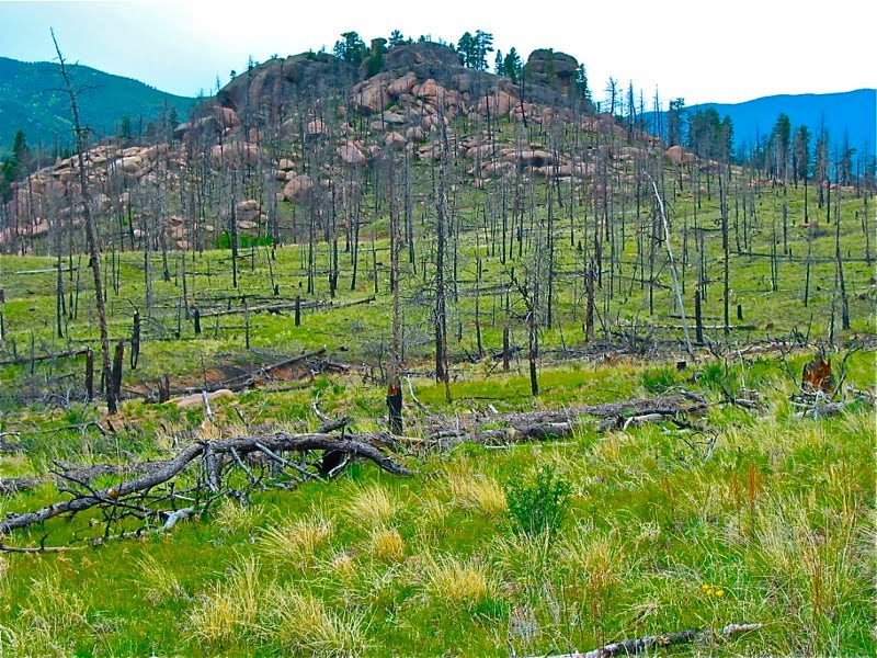
Verdant green grasses disguise the horror of the fire that blazed through the Buffalo Creek area

In 2004, I went camping over the Memorial Day weekend in the Buffalo Campground near Buffalo Creek. A friend and I went hiking on several of the trails in the area. One day we took a long hike that was a loop through the charred remains of a forest. I have had pictures from this hike sitting in an archive not knowing what to do with them. Our route was lost in the sands of time, ground into the soles of my boots.

Then, the other night I bought a topo map of the area for a hike we were planning for Thanksgiving day and I started studying it. I realized the trail we did that weekend was the Gashouse Gulch-Baldy Trail Loop. We walked the loop counterclockwise starting at the Gashouse Gulch trail head.

A distant rock formation. Would you have known it was there?

Mostly listed in mountain biking books, this trail is also accessible to hikers, in fact we saw many while there. Its topography changes from a Martian burnt-out landscape to lush Aspens forest. Throughout are the sandstone rock formations characteristic of the Lost Creek Wilderness Area (just to the southwest).

A trail segment

By far the most interesting aspect of this hike is the burn zone. Huge piles of rocks that would have been hidden by trees were suddenly visible through the burned out stumps. I felt like a voyeur, peeking into Mother Nature's lingerie drawer. Somehow I could tell that this geology was never meant to be seen so openly by human eyes. The weather that day was characteristically schizophrenic. We put on layers, we took them off, we put them on and took them off again in an endless cycle. Was this Mother Nature sighing at our intrusion and the folly of man that lade bear her secret places?


Map showing the extent of the Buffalo Creek Fire (1996) and the High Meadows Fire (2000). Click on the image for a larger view. You can also see this loop and other trails in the area.

The Buffalo Creek fire occurred in 1996 and burned 12,000 acres. It burned very hot and most of the trees were totally destroyed. While grasses returned within six years, it will take a century or more for the trees to return.

A hidden knoll. Hmmm, does Mother Nature have cellulite?

I took these photos long before I started blogging and they do not represent a complete picture of the route. In fact they only represent the first couple of miles that are within the burn zone. Still, since it may be a very long time indeed before I ever retrace my steps and this trail is not well known, I decided to post them anyway.

If you decide to camp near Buffalo Creek, give this trail a try. Just bring plenty of water. There was none in the campground despite advertising to the contrary and the camp hosts were making a killing selling jugs of the stuff. Folly of man indeed.

Selasa, 24 November 2009

Monument Valley

The world fameous view of the approach to Monument Valley. Everyone stops and takes pictures from the center of the road.

The drive into Monument Valley is one of the iconic images of the American Southwest. I journeyed there a couple of years ago on the way to the Grand Canyon. Not really a valley, the area is really a broad, flat plane out of which rises red wind-carved buttes of astounding beauty.


Looking at the Mittens from the road

The "Mittens" are the most recognizable images from Monument Valley.

The entire valley is on a Navajo Indian Reservation and to see it properly, you need to get off the road, pay the 5 bucks and drive the 17-mile dirt valley drive. This drive winds through towering cliffs, yucca, and red-blown sand. Periodically, you'll come across locals selling hand-made jewelry.

Yucca in bloom
This spot had been particularly photographed. You can tell by all the foot prints in the red dust.

There is one short 3.2 mile hike in the area, but since we were in transit, we did not take it. The drive itself has 11 stops and takes a couple of hours. It is rough but was passable by my sedan. Several of my fellow travelers got up before dawn to hit the area at sunrise. Alas, no astounding pictures resulted from their sleep deprivation.

The Valley Drive enables you to see many of the same formations from different angles.

Even in the desert, flowers bloom

Selasa, 10 November 2009

Avatare messenger cu Mos Craciun

Iarna a venit de ceva timp si impreuna cu ea vin Sarbatorile de Iarna si Mos Craciun. 
M-am gandit ca ar fi util sa pun si cateva avatare cu Mos Craciun pnetru Yahoo Messenger si forumuri.
Majoritatea avatarelor sunt cu Santa Claus in diferite ipostaze comice.


Nu uitati sa trimiteti si prieteniilor adresa de unde ati luat avataru pentru mess.

Staircase Rapids Loop

Distance: 2 miles round trip
Critters: Banana Slugs
Flora: More ferns than you can shake a stick at

Sunlight only dimly reaches the floor of the forest on the Staircase Rapids Loop

While on business to the Ft. Lewis area of Washington State last month, I took a day to explore the area. I wanted to set foot in Olympic National Park and so I drove to the Staircase Area, which took me about an hour. My original intent was to hike the Hoh Rainforest, but that trailhead was 3 hours away. Let me tell you that the Olympic Peninsula is big!

Lake Cushman borders the route to the Grand Staircase area

Moss and ferns, moss and ferns!

I started freaking out the moment I stepped onto the Staircase Rapids Trail. The trees were the size of skyscrapers, the ferns the size of Volkswagen Beetles, and the moss looked like it would reach out smother you if you stood still too long. The forest was so dense that 10 Sasquatches could have been hiding behind each tree and you never would know it. I kept waiting for a giant Banana Slug to leap out and cover me in a blanket of slime. Step off the trail in this forest and you would be lost for the next 10,000 years. They would never even find your bones! And this was only 1 mile into the wilderness!

Typical Trail Segments


The Staircase Rapids Trail follows the Skokomish River and winds in and out of dense trees. The bridge was out at the far end, and although I had planned on fording the stream, decided not to when I saw the speed of the current and the large rocks I would have had to walk on. I am not sure the trail would have been much different on the other side. The forest seemed uniformly green to me. Sigh, I am such a spoiled Coloradan. In Colorado, as all my blog posts will attest, the scenery is forever changing. I wonder if I would get bored hiking on the Olympic Peninsula if that is where I lived.

Bark of the Red Cedar Tree

Sunlight glinting through the moss

I did find myself being drawn to the micro-scale since the macro-scale was so monotonous. This too can be hazardous. Some fellow hikers discovered me ignominiously buttocks up, face down in a pile of moss. I told them I was fascinated by the forest within a forest. From their facial expressions, I could tell they thought I was rooting around for magic mushrooms like some truffle happy pig.

Ferns!!


I had planned to spend the entire day in this area but decided to take the plunge and drive out to the coast instead. That was a very long drive indeed. Did I mention that the Olympic Peninsula is big?


Fungi with the river in the background

If you go to the staircase area, be advised that you may feel like you will never get there, or worse that you are lost on the back roads. There are very few signs guiding you to the park, and the main route travels besides Lake Cushman and all the splitter roads leading to lake-side cabins. The road also turns to dirt before it returns to pavement just before the entrance. That was particularly disconcerting.


River views


Rare glimpse of the Skokomish River in full sunlight

In the Staircase are is a ranger station and a bathroom, but no ranger on duty per say. There are maps to the entire park on the door to the cottage but the trail I was on was dwarfed by the scale of entire park. There are more strenuous trails in the area as well. To get to Wilson Lake, one hikes two miles with nearly 4,000 ft elevation gain. That is a 14er by Colorado standards. If the entire trip wasn't in the trees, I might have chosen that trail as an option.
Diberdayakan oleh Blogger.

Pengikut